You are currently browsing the tag archive for the ‘Day Peckinpaugh’ tag.
How many times do I have to look before I see? Click here for the post from a few days ago, where I saw a barge and a Moran tugboat. Granted, it was snowy. But I missed

seeing/correctly interpreting the puff of black smoke on the far side of the barge. Also, I missed the white superstructure and mast as well as a tugboat stern lower right projecting beyond the rake of the barge.

Yesterday, thanks to Bjoern of New York Media Boat, here’s a photo of what was on the far side of the barge. Denise Foss was there all along in that photo from Saturday, but it took actually seeing it all from this perspective to “see” that. Her sister Michele, older by one year, is currently working at Vineyard Wind, south of Martha’s Vineyard.

Many thanks to Bjoern for this photo.
Unrelated: If you’re interested in Day Peckinpaugh, consider registering here for an online Erie Canal Museum Lunchtime Lecture tomorrow, January 25, at noon.
The Great North River Tugboat Race isn’t happening this weekend, but Waterford NY’s Tugboat Round Up will certainly be in a week. It’s been somewhat rebranded as the more manageable phrase TBR. Information about it and other upriver festivals can be found here too. For today, enjoy some photos I took at the 2013 TBR.
For example, this was my first time to see Grande Caribe heading into lock E-2; little did I know then that I would later be aboard this vessel and its sister for thousands of miles and hundreds of lockings-through. I can’t look at all the other boats along the right side of the photo and not think about all the changes and losses; of course, I also recall all the joy I felt there then and during other years.


Friday of the festival, a parade begins near the port of Albany. Dean Reinauer, with RTC 106, was getting a spin-around at the turning basin, assisted by Kathleen Turecamo. None of those vessels were part of the parade.

Governor Cleveland was, however.


Herbert P. Brake was too, here pushing HR-Bass. Brake would go on to become Rebecca Ann, and Bass became Betty D. It seems that Brake has now re-assumed its original 1992 name.

Gowanus Bay was a regular for a few years.

Among the small tugs were Iron Chief and Atlantic Hunter.

Cornell was there.

In front of Cornell were NYS Marine Highway Frances and Margot.

Back then, no TBR was complete without checking on Day-Peckinpaugh and Urger. Again, I had no idea in 2013 that I’d spend five months working on Urger or that in 2023, the future of Peckinpaugh would be so bleak.

As seen from the other side, Tappan Zee II was in the dry dock and would soon be part of the construction of the new TZ Bridge.

All photos and memories, any errors, WVD, who is currently down bound on Lake Erie about two hours behind J Arnold Witte, who will likely be at the 2023 TBR next weekend. She’s just starting through the Welland Canal as of this writing. I’ve no confirmation of that; I’m only speculating because of her timing and heading. As for me, I’m heading for Montreal, so I’ll miss the TBR.
If you want to see all the tugster photos from that year, click here.
At some point, maybe days before April 23, 1921, at McDougall Duluth Shipyard, this vessel, Interwaterways Line Incorporated 101, or ILI 101, had taken shape on the ways.

After it slid down the ways at launch, it was followed by four sisters, all before summer began in 1921. The 101 traveled via the Soo, three Great Lakes, and the Barge Canal to New York with 83,000 bushels of oats (approximately 1300 tons… count the trucks or rail cars) at a rate 60% below the railroad cost.

As you can read below, 101 was the “advance courier of a fleet of new type of ships,” freighters specifically designed to transit the newly opened Barge Canal or Eriemax vessels.

The telegram below details of communication between 101 management and Canal management regarding a “representative familiar with the canal” aboard. I’m wondering if this was a way of saying they needed a pilot, someone with relevant local knowledge.


That initial transit was made eastbound with wooden tugboat Lorraine.

Between 1910 and 1920, the time of the opening of the Barge Canal, the population of Fairport grew by almost 50%. Note the low profile cargo hatches on the vessel at this time.

Later in August 1921, spectators were photographed coming to see her at E-21. The steering pole hints at her Great Lakes roots.

Through the years, a number of modifications, detailed here, were made to the freight ship. She was renamed Richard J. Barnes and later Day Peckinpaugh, her current name. As Barnes, she carried coal along the East Coast and once dodged a torpedo launched from a German submarine.
1959? Here she is just below lock E2 and the “flight of five” in Waterford. All the other commercial vessels behind them, stretching all the way back to the Hudson River, I’ve read they are stuck there because of an issue with another lock in the flight. In other words, this is a smaller version of the back up a month ago due to Ever Given in the Suez Canal.

Also note in the photo above tug Urger on the opposite side of the channel. Urger is no stranger to this blog and, in my opinion, another critically endangered vessel with a NYS Canal history. I worked as deckhand on Urger for the 2014 season, when she was in her 113th year.
1963. Here she is northbound on the Oswego Canal at Phoenix NY.

1994. Eastbound at Rome NY with her last load of cement, the only type of cargo she carried from 1961 until 1994, she passes the freighhouse, now incorporated into Bellamy Harbor Park. The terminal lies less than a mile ahead, off her portside. At a special widening ahead either before or after discharging cargo, she’d turn around. Compare her special cement hatch/manifold arrangement below with the configuration in the photo taken in Fairport in 1921.

1994. Here’s a video still of her exiting a lock after having discharged her last cargo, heading home, so to speak, to an uncertain future.

2005. After more than a decade being “laid up” in Erie PA and just before she might have been scrapped, she was purchased by an alliance that included the New York State Museum, the Canal Society of New York State, the New York State Canal Corporation, the Erie Canalway National Heritage Corridor Commission, the New York State Office of Parks, Recreation, and Historic Preservation, and New York State Marine Highway Transportation Co., Inc. On this trip to a new role, the 84-year-old freighter was escorted by Benjamin Elliott, as she had been by Lorraine 84 years earlier. I missed this, but from accounts I’ve heard, this was a triumphal return. She’s currently an accessioned artifact of the New York State Museum.

2005. From that same voyage, she exits the downside of lock E17.

2009. During the year of the Hudson-Fulton-Champlain Quadricentennial, she traveled under her own power as far south as the sixth boro of NYC and Plattsburgh on Lake Champlain.

2009. I took this photo of her hold, a vast space that has potential as an exhibit space inside a traveling artifact from NYS canal history, whose history demonstrates the connection the Erie Canal makes between the Great Lakes and salt waters.


2021. She’s still afloat, raised from the bottom of the canal as a result of the routine annual winter lowering of water level. She’s afloat for her one hundredth spring, but needs her potential recognized once again. Stan Rogers wrote a song performed here by Makem and Clancy that captures the attitude needed to rekindle the flame, clarifies the vision, and saves her from the scrappers or the reef. Maybe someone from the New York State Museum can comment on their vision for this last of her type. A sister vessel, ILI 105 lies rusting away in Staten Island.

Some of my previous posts on the vessel can be seen here. Many thanks to all who contributed photos to this post: Paul Strubeck, John Callahan, Craig Williams. Any opinions are my own and any errors mine as well.
One goal I have for this post is to try to unearth more images of this vessel pre-1994. Anyone help?
First, see these three photos from 2009 with updates. I passed by this spot in Seaford DE this past week . . . on a mission, and the former Flagship Nanticoke Queen restaurant is no more. Only a graded lot remains where the USS McKeever Brothers (SP-683) WW1 patrol and minesweeper vessel and fishing boat both before that and after the war once was. Route 13 has a bit less character. The wooden hull was likely buried in a landfill.

From 2009, this is the 1958 Jakobson-built Dalzelleagle and then McAllister Brothers. And yesterday, she was was towed away to be scrapped. At temperatures between 2500 and 2750°F, that steel will puddle and take new shapes. Tomorrow I’ll post more photos of this 1958 beauty.

Another photo from 2009 of the 1907 Pegasus . . . now also history and headed for the same high temperatures and red hot puddles.

A photo from 2012 . . . Siberian Sea, still afloat, and currently called Mike Azzolino.

Also still extant, in fact, David Silver took this photo less than a week ago, the May 1921 launched Day Peckinpaugh. Yes, that is the Erie Canal between Locks E2 and E3. The canal water level is drawn down in the winter/spring for maintenance.

May 21, 1921 precisely was the day Interwaterways 101 came off the ways at the McDougall-Duluth Company shipyard. Shouldn’t we hold a socially distanced party for the freight ship?

Here was the neat and active Eriemax freighter in 1961.

Thanks to David and Craig for use of their Day Peckinpaugh photos; the others from 2009 and 2012, WVD.
As to the tragedy of 231′ x 71′ Seacor Power, Seacor Supporter, 131′ x 66′ , came to do some work in the sixth boro here a few years ago. Brazos is 145′ x 100′.
In fall 2010, deepening dredging was happening in the sixth boro to prepare for the ULCVs now so commonplace here, after Panama Canal enlargement and Bayonne Bridge raising. These operations afforded me the chance to see a cutterhead close up. The crewman wielding the hammer was trying to loosen a worn tooth. By the way, those teeth weigh 35 pounds each. Teeth . . . dentist?

Then as now, Layla Renee was in the dredge support trade. Right now she’s in Charleston. She was only two years old at the time of the photo.

It looks that way, but W. O. Decker is NOT a dredge tender in this photo. Here five people on Decker are catching the stare of the one dredge worker in work vest.

The entire K-Sea fleet has disappeared. As of 2020, Falcon has become Carol and I’ve not yet seen her latest livery. Houma was scrapped in 2017 in Baltimore.

Here are two of the McAllister tugs involved in easing MSC’s USNS Sisler (T-AKR 311)into Bayonne drydock as then-John P. Brown manages the door. For many more photos of the event, check out “floating the door,” where you also see Allied’s Sea Raven, unlabelled.

I caught Growler at Mystic Seaport that fall. Rumor has it that Growler has returned to the sixth boro under a new name and sans teeth, but is under wraps.

Also in Mystic at that time, 1885 steam/sail vessel Amazon (has nothing to do with Bezos), the 2000 Amistad, and the 1908 steamer Sabino. Does anyone know the whereabouts of Amazon today?

My reason to be in Mystic that October was to work on Pegasus, seen here with Araminta and Cangarda. What works of beauty all three are!

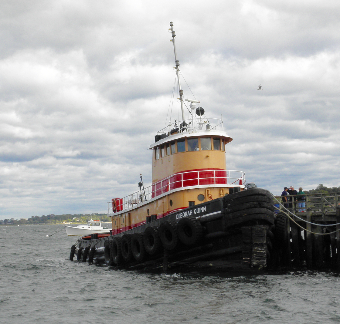
Deborah Quinn here is docked near where Jakobson Shipyard used to be located. I believe that’s her location as of this writing.
Under the old Bayonne bridge, Maurania III assumes position to ease the 1997 Maersk Kokura around Bergen Point. Maurania III is currently in Wilmington NC.

Back a decade ago, Day Peckinpaugh had some good paint on her, and Frances was like a cocoon in Turecamo livery. There’s scuttlebutt of a new lease on life for Day Peckinpaugh.

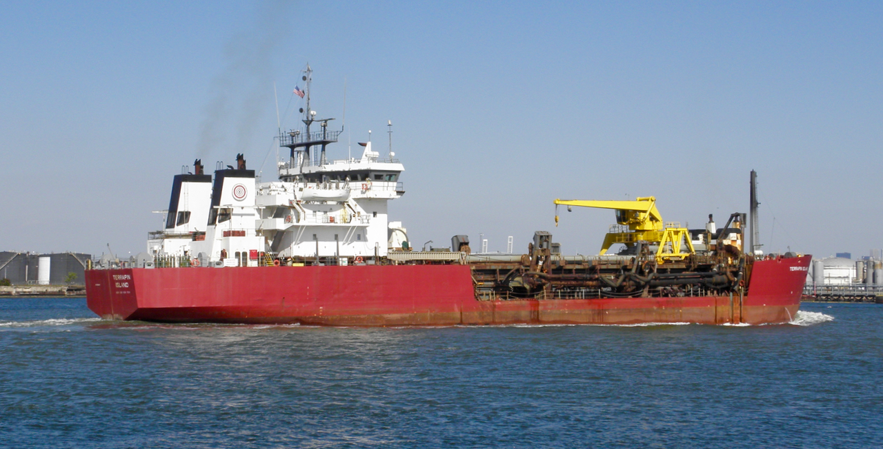
Let’s end with dredging, as we began. Terrapin Island was one of the regulars in the navigation dredging effort. Terrapin Island is currently in Norfolk.
All photos, October 2010, by WVD.
Big announcement soon.
An omen of the future . . . in 2013, Urger was laid up, sans her problematic prop shaft. Here she’s nez-a-nez with Day Peckinpaugh.
Gowanus Bay was looking good.

NYS Marine Highway was well represented,

as always. And following two of the four NYS Marine Highway boats there was Cornell, Frances and Margot‘s senior by the better part of a decade.

If you’ve never attended, trust me when I say the fireworks show is extraordinary! Here from the bulkhead a dozen or so thousand spectators

and a few on solo craft

are captivated by the show.

I can’t tell you much about Iron Chief, except that it has nice brass, a working steam engine, and was for sale in 2012. In that link, you hear it run. Of course, in the distance that’s ex-Atlantic Hunter, now Little Giant.

For me personally, 2013 was my first time to see the Blount Small Ship Adventures vessels head into a lock.


Besides tugboats, you never know what or who you might see.

it’s bowsprite of the blog and the etsy shop on an underwater mission.

Here’s the line up.

All photos, WVD.
Please, Lord, no . . . Day-Peckinpaugh has not been put out to pasture, I hope . . .

“Out to pasture or not,” as Craig said, soon someone will have to start mowing the grass around her hull. Maybe green goats can help? This photo was taken between locks E-2 and E-3 a week or two ago.

Here’s the Erie Canal between E-28A and E-28B. In normal seasons, by this time (photo taken in late May) the water would be from top of riprap to top of riprap on the other side. I hope to hike it, in search of treasure, evidence, or . . . just plain junk.

Here, looking west, is the top of the Lyons dry dock to the left and the top of E-28A to the right. For a photo of DonJon tug Rebecca Ann on that wall between the dry dock and the lock, click here. I took that photo August 2019.

This is a great place to catch walleye . . . or was. That’s lock E-27 to the left.

Right near this bridge, I got a photo of a buck swimming across the canal just ahead of the tugboat here.

So why is there no water over the spillway here? Why are the levels so low in the other photos in this post? The canal was de-watered at the end of the last season. This is done each winter so that maintenance and repair can be done in the winter. That was ongoing last winter until mid-March when the state classified canal workers as non-essential. All work stopped until very recently. So all disassembly that happened last winter is now late in being reassembled.

Until the canal gets re-watered, it’ll make for some interesting hiking.


Many thanks to Craig Williams and Bob Stopper for these photos.
And if you’ve not yet watched the Turnstile Tours talk I did back on May 26, have a watch here. It’ll take about an hour. That’ll be in lieu of blog posts the next days, weeks . . . however long this retreat takes. I’ll be back . . .
Here are the previous posts in this series. Let me call this vessel what it is: the last Barge Canal bulk carrier, launched on May 21, 1921 as Interwaterways 101,

the first of five, built at the farthest end of the Great Lakes, Duluth. Less than a week ago, she celebrated her 99th birthday. She worked as the last bulk carrier on the canal until 1994. Her work history is delightfully told in the documentary Era of the Erie #3 embedded at the end of this post.
Below, photo from June 8, 1921 at what was likely a “meet and greet” at the start of her inaugural trip into the new Barge Canal and system. Those are not the hats and coats of workingmen.

Less than a week later, she’s eastbound in Fairport towed by Cowles Towing Line‘s Lorraine.

Continuing eastbound, she’s departing lock E21 into the summit level. Comparing the photo above and below, I’d say it’s warm, and the hatch with portholes has been raised to increase ventilation. That was air-conditioning in 1921. Also, that was prior to the national electric grid, so lock 21, like all the locks, created its own DC power from water turbines. I love ILI 101‘s steering pole here; it’s very Great Lakes.

This “aerial” was taken from the top of the “guillotine” gate at lock E17. The “faces” in the rock at Moss Island are unmistakeable.

This “aerial” from the east end of lock E7 allows a good view of the stern.

Here she has departed the Barge Canal and is lying alongside a wall in the port of Albany. Notable is the horse and carriage here, and

the Model-T era automobiles here. Cowles Towing Line’s Lorraine appears to have taken ILI-101 on a transit of the Barge Canal. ILI 101 was renamed Richard J. Barnes in 1936 and Day Peckinpaugh in 1958.

As a final treat, click on the image below to see and hear Day Peckinpaugh, the last Barge Canal bulk carrier, under way. She is a NYS treasure and we should monitor her future.

And for the pièce de résistance, click on the image below for an excellent half hour documentary on her place in the Barge Canal era. For more by Low Bridge Productions, click here.

Many thanks to Craig Williams and the NYS Archives for these images.
Three Rivers Junction, where the Seneca meets the Oneida, forming the Oswego, it’s got to be right around that bend.

At Three Rivers we sail into our own wake; we’ve performed the ouroboros. There’s just this sign, which we saw on leg 9 of the earlier virtual tour. No pier, no quay, no wharf, no concession stand . . . no place or reason to stop. Different groups of the Haudenosaunee may have had their names for this convergence, but I’ve not learned any. The inn that was here, off the left side, has never been replaced.
If we turn north here, we return to Oswego. If we turn east, we head for Waterford. I know a boat currently in the Pacific that was right here coming from Lake Erie/Buffalo seven years ago, and turned east here. Arriving from Lake Erie, about 200 miles back, meant getting lowered 200.’ From here to Waterford means about 160 miles, but we have to be raised about 60,’ and then lowered about 400.’ Quo vadis?

This is the end of the line. Thanks for coming on the virtual tour.
I hope you carry away a sense of the beauty and variety of this corridor, which you won’t see from the NYS Thruway or even the Empire State Trail. Part of my goal was to help virtual travelers see a past, present, and future microcosm of the tangled evolution of this continent. Conflicts and other events happened here between indigenous peoples, then between Indigenous and European, then Europeans tangled with each other, and finally schisms arose and continue to arise between different descendants of settlers. Infrastructure innovates and then becomes vestigial, to be left or removed or reimagined and repurposed. This tremendous although seasonal thoroughfare got built and evolved. As of 2020, the locks can still be made to accommodate vessels up to 300′ x 43.5′ with water draft to 9′ and air draft 15.6′. If SC-330 existed, it could still make a real trip from salt water back to Manitowoc WI. I’ve included photos of some fairly large vessels in these two virtual tours.
I end here at the crossroads (or crossrivers, more accurately) because the waterway is at a fork, a decision point, in its history. One future is the status quo or better, another future might see it become vestigial, i.e., the end of the line. Either way, some role evolves. Here‘s a description of the state’s ideas just four months ago, although given Covid-19’s appearance, that January 2020 speech seems like years ago.
Some speculate, Article XV of the NYS Constitution notwithstanding, that we face the Erie Canal’s disappearance as a thoroughfare. It DOES cost taxpayer money to operate and maintain even if transiting recreational vessels pay no fees, said to be the case through 2021. Since 2017 recreational boaters have paid no tolls; before that, fees were very low, especially calculated as a percentage of the value of some of the yachts I’ve seen transiting. Commercial vessels pay, although the tolls are small compared to those in Panama. Also, the sheer number of recreational boats has declined since a high of 163k in 2002; in 2018, 71k transited locks/lift bridges. In that link, this: “The figures account for each time a boat goes through a lock or under a lift bridge, not the actual number of boats. If a boat travels through several locks, it would be counted as locking through each time. The numbers also do not account for boaters who only travel locally and do not go through a lock. A large percentage of boating traffic falls into this category.” I’d love the be able to unpack those numbers further.
If tolls cover 5% of the budget, remaining 95% … a lot of money … needs to come from somewhere else.
This navigation season would normally have begun next week around May 15. That will not and can not happen this year, a direct result of NY-on-pause policies implemented to combat Covid-19 spread, and I support those policies. But canal maintenance projects that involved draining (de-watering) sections of the canal (remember guard gates and moveable dams?) and disassembling some locks, severing the canal, are not finished. But what if the canal never opens as a thoroughfare at all in 2020? In May 7, 2020 Buffalo News‘ Thomas J. Prohaska reports that eighteen legislators from canal communities across the state have written NYPA calling for full opening this season of the thoroughfare. It would be the first time that it has not opened since 1825. It’s undeniable that March and April 2020 for New Yorkers as well as folks in the rest of the US and the world have been unprecedented. Just earlier this week in central NY a hot spot appeared among construction and agriculture workers. But we will go back to the way things were, right? Recent special funding stemming from Re-Imagine the Canal focus, though, seems to be going to non-navigational projects, ones that look at the water rather than ones that enhance the thoroughfare. To be fair, the strategy seems to be to increase reasons to come to the water in hopes that this will increase usage of the water, the locks, and the lift bridges.
Will this be the 1918 canal in 2118 or sooner, ruins in a countryside park, places to make people reflect on their mortality?

Will it be sublime views of nature reclaiming its space? There’s intermittent water but no thoroughfare, a severed waterway, and eventually

it’s gone, reborn or devolved into a gully or a bog.

We choose. We have voices. We have fantastic 21st century writing, communication tools to speak to “deciders.”
These posts have been my individual effort during the “Covid-19 pause” to share a draft of a project I had imagined would involve augmented reality. This has been my way to stay indoors and busy during this unprecedented time. Many of you have helped over the years, have shaped my perception and understanding on this place. You know who you are and I thank you.
If you’re interested in learning more about this waterway, consider joining the Canal Society of New York, an organization that’s existed since 1956, and holds yearly conferences and field trips along the waterway. Their website has lots of information and many useful links.
If you want more detail about the canal from Eriecanalway.org‘s application to the US Dept of the Interior/National Park Service in reference to the New York State Barge Canal Historic District, click here and start in section 7.
I plead guilty to multiloquium here, so let me end with a set of my photos I’ve taken along the Erie Canal, a treasured thoroughfare as much now as in 1825.
Dancing by the river,

skimming through the system,

looping together,

paddling as far as you want,

transiting from seas to inland sea,

waiting timeless bateaux ,

max’ing the dimensions

solo shelling,

Hudson boat getting raised at lock E-17,

Canadian boat heading for the St. Lawrence,

awaiting passengers to summit the thoroughfare,

stopping for regional treats,

exploring the middle of the thoroughfare,

using minimalist power,

repositioning delivery,

mustering,

returning from a tow,

locking through at season’s start,

fishing in the shade,

frolicking on fantasy fiesta floats,

simply yachting,

squeezing through and under and above,

bringing tools to a job,

rowing a home-built,

locking Urger through for at least the 10,000th time,

raising money from Buffalo to Burlington VT,

[your tour guide] tending line . . .

the air guides standing vigil, and

the misunderstood “monsters” preparing to plumb the depths of the canal, just some of the things that happen here. This last photo is for TIB, who wanted to know.

Preface: There’s a new heading at top of the page called “virtual tour.” Covid-19 has changed everything. Now it’s not alarming to walk into a bank or business establishment wearing a mask. Many people commute from bedroom to desk, and a really long commute is one that involves stairs. I’ve been to a few remote concerts already this week, and virtual travel is happening without getting beamed up or down. Webinars and Virtual guides are popping up everywhere, and zooming has a whole new meaning.
Today I begin posting a “virtual tour” across New York state by the waterway that changed our national history. You don’t need a ticket or a passport or a subscription. We’ll take some zigs into the surrounding land, and some zags into history because we don’t need to stay between the channel markers. Transit from the Hudson River to Lake Ontario will take ten posts, ten days. Also, to avoid confusion, click here to find the distinction between 1825 Clinton’s Ditch, the 1862 Enlarged Erie Canal, and the 1918 Barge Canal, today often referred to as the Erie Canal. I’ll point out some vestiges of the 19th-century waterway. That distinction and other terms are defined here. Yes, some parts of the canal have been filled in, but those parts were obsolete already. Sal would certainly saunter along if he could, but he’s got other duties. Besides, Sal’s been replaced by Cats and Cummins and other mechanical critters.

Here’s a good place to start: a weathered and water-stained distance table I saw in the wheelhouse of 1932 Canal tug Seneca. Although I don’t know the date of printing, the table clearly comes from a time when commercial traffic on the Canal made runs between the sixth boro to Lakes Erie and Ontario routine. I’ll refer to it for distances now and again. In this series, we’ll head to Three Rivers Point, and then take the Oswego Canal/River to Lake Ontario.

We’ll begin just south of Waterford, the eastern terminus of the current Canal. Approaching from Troy on the Hudson, you’ll see

this sign in the town of Waterford indicating the entrance to the Canal, branching off to port.

Waterford, a town of just under 9000, is a fantastic stopping point for boats even today. Note the red brick visitor’s center and just to the right, the bridge leading over to Peebles Island. That Second Street/Delaware Ave bridge links this to a few photos farther below, taken decades apart.

Before plunging into history, have a look at where these boats come from. Double click on most photos to get larger version. Often recreational boats,sometimes loopers, tie up there for information and provisioning; international yachts . . .

Great Lakes work boats,

and self-described slow rollers. We’ll roll quite slow too, to smell the flowers and avoid . . you know . . what Sal might’ve left behind.

To this day, commercial vessels that can squeeze under the 112th Street Bridge congregate in Waterford in early September each year for the Tugboat Roundup.

Can you spot the one tugboat that appears in both photos, above and below, taken more than a half century apart? It’s Urger, whose story is long and involved and can be deciphered here. The self-propelled barge, aka Eriemax freighter, on the wall to the right is Day-Peckinpaugh, which transported cargo on the canal from 1921. She’ll come up again later in the trip.

Note the same Peebles Island bridge? Judging by the barges, I’d place this photo at about a century old, back when the Barge Canal-iteration of the Erie Canal opened. The archival photos throughout the series come from the Digital Collections of the New York State Archives, and this is my credit. Visit the New York State Museum also virtually here.

In the next post, we enter the flight. For now, let’s hail the lock master on VHF and see if he’ll open gates. Click on the link in the previous sentence, and scroll, to see the friendliest lock master in my experience; as with anything, your experience maybe different. .
Consider this a work in progress. Nycanals.com maintains extensive info about every lock in the journey on their site.
Any additions, corrections, or other comments are appreciated. I have literally thousands of photos of the canal, but would welcome your best as well. I’d love to make this an ever-growing communal project. Let me add one more from the 2008 Waterford Tugboat Roundup.

Again, black/white photos from New York State Archives, Digital Collections. Color photos WVD, unless otherwise stated.
Fred of tug44 created a systematic tour here several years ago. Sally W went through the same itinerary from June 11 until 22 in2012.


Recent Comments