You are currently browsing the category archive for the ‘Blount Marine’ category.
Almost seven years ago, I posted Go West, the announcement of my employment as onboard lecturer for Blount Small Ships Adventures. Dozens of posts followed between that date and fall 2019. Here’s my Go West at start of 2017 post. Then Covid-19 happened, and Blount decided to close their passenger vessel excursion business in spring 2020 and later to sell their fleet.
Today, I’m announcing that I have similar employment with American Queen Voyages, departing the sixth boro tomorrow by air for New Brunswick, initially. My title is “lakelorian,” a nom de voyage I share with several other folks. It’s a variation on “riverlorian,” used by lecturers on American Queen excursions on the Mississippi. Roundabout? Well, we head NE to get SW, and that’s after traveling from flying from LaGuardia to Toronto and then Saint John, crossing two international borders before getting to Eastport ME. More later, I hope.
This is a short post to announce that I expect to be out of the sixth boro much of the time from now until well into fall. I also expect to have WiFi at least sometimes, so I can post photos of noteworthy sights along new/old waterways as well as sixth boro events if you take and pass them along. In fact, if any sixthborolorian relief crew wish to step up, let’s communicate.
Meanwhile, as I step into the new, here’s glance back at the old, all photos of two of the Blount boats from 2019, their last year in service. Here’s Grande Mariner in lake mode, but
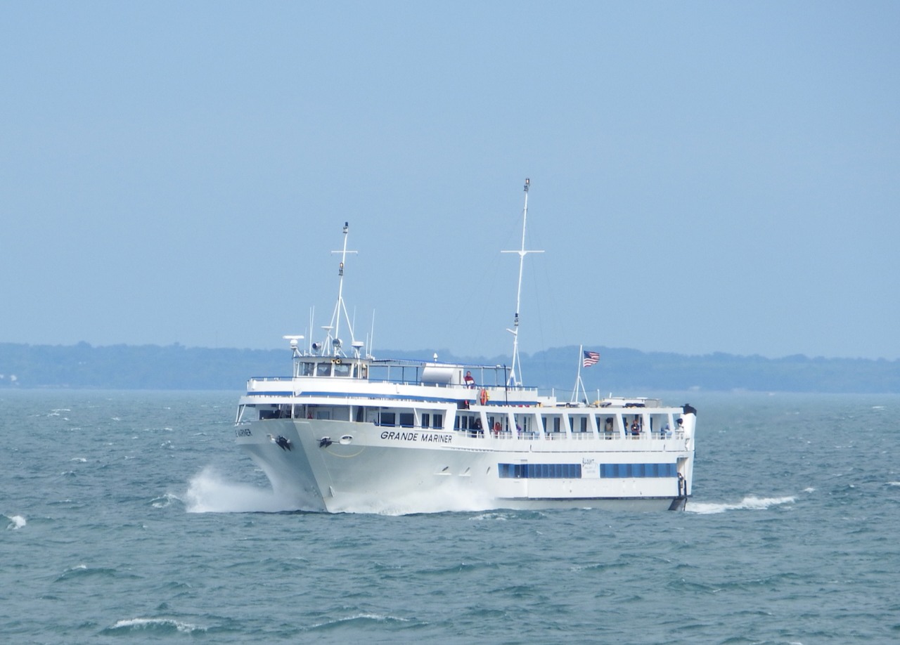
they are able to morph into NYS Canals mode and squeeze under and

through; I’ll miss

those waterways.

All photos, WVD, who’s about to wear a new hat and may be incommunicado for a bit. Here’s the new ride . . .

If you’re unfamiliar with NYC, most of the photos in this series are from Roosevelt Island, likely off most visitors’ list of places to see. That’s too bad, since it offers a lot, including great views of Manhattan and the strait (East “river”) in between. If you’ve not seen the Nelly Bly memorial at the north end, you’re in for a treat.
Here are previous posts in this series. Let’s start with the NYS-built Ava Jude, a 600 hp boat not seen on this blog in a while.

It’s also been a while since Shannon Dann was last on the blog, but that’s because she has had her 2400 hp engines working elsewhere.

Ava Jude‘s 1200 hp fleet mate, William Brewster, has been working on the bulkhead project under the 79th Street bridge for some time.

This Brooklyn, a Vane boat now but formerly Labrador Sea , also brings 2400 hp to the task, and like Brewster, is Blount built.

I notice King’s Point‘s training vessel too late to get a side profile shot, but her “name” 142, is a number of great significance at the USMMA. If you click on no other link in this post, do click on that one.

Coastline’s Kodi is another New England (Gladding Hearn) built small tugboat, the perfect boat for certain jobs.

See more Gladding Hearn boats here, although that’s not a complete list, since I notice that Benjamin Elliot and others are missing in that link.

Michael L. Daigle has appeared on this blog only about once before. She’s a 4200 hp boat that once wore Kirby colors on the west coast as Mount Bona, named for a major North American peak in Alaska.


All photos and any errors, WVD.
Happy 120 years old, Urger! I urge you to read the note at the bottom of this post.
And . . . .Oops! I read the timer wrong. Bidding for Grouper, in Lyons NY, ends about six hours from now.
Lyons is a county seat, but it’s possible to take a photo of lock E-27, right in the town, such that it appears to be rural. A row of buildings to the right separates the canal here from a major street, Water Street; to the left, there’s a strip mall along NY-31.

Lyons is the home of Muralmania, and it shows; this was one of two murals just west of lock E-27. The next lock, E-28A, is about a mile away.

Just before getting to lock E-28A, you see the section workshop buildings.

That’s Route 31 paralleling the canal.

At the top of the lock chamber, you have a great view over into the Lyons Dry dock. Whatever is in the dry dock during the navigation season is surplus, in need of repair, or beyond repair. Grouper is there, its rusty stack with its yellow ring visible in the foreground.

Staged and waiting for deployment are a set of tugboats, dredges, and a quarters barge aka “floating lodging,” like the one being auctioned off with bidding ending late this afternoon. To repeat, I’d misreported closing of bidding in an earlier post, but today it ends.

We negotiate another low rail bridge before coming up to lock E-28B, about 4 miles to the west of E-28A.


In the port of Newark, I catch up to Sweet Love, a small trawler I caught at the Narrows last August. The lovely storefronts in the village disappeared thanks to the misguided efforts in the 1960s called “urban renewal.”

West of Newark at Wide Waters is the hamlet of Port Gibson, Ontario County’s only port along the Erie Canal. During the 19th-century iteration of the canal, this was a port.

The bridge here has just been refurbished.

From there, the canal narrows as we head west. The rain started falling as well.


We had miles and locks to go, but we called the trip “over” when we got to the Port of Palmyra, because of a breach in a spillway ahead.

All photos, WVD.
Sign the card here to celebrate Urger‘s 120 years. Its future too is threatened.
Here I get to prove once again that you can never step into the same river twice, or you can never see the same stretch of canal the same way twice. Click here to see what I did with previous set of photos.
The photo below was taken from the NE corner of the triangular island I’ll now call Midway Junction (the CS and Erie Canals meet here), Midway Triangle, or (my contribution) Tadadaho Island, if you want to learn about this indigenous spiritual leader, click here.

Two miles west from Tadadaho Island, we approach Lock E-25 in

May’s Point NY. Click here to see the location of the lock relative to the NYS Thruway.

What would you expect to see when the lock is in a National Wildlife Refuge?

A small boat could cross here and enter Tschache (“shockey”) Pool.

There’s a campground and marina here.

Lots of these and other wildlife are here. Someone on the boat saw a coyote on the south bank.

The Clyde River intersects the Erie Canal several times. Follow the channel markers.

About six miles farther, lock E-26 appears.

See that rusty bridge a quarter mile beyond the lock?

It’s the E-93 West Shore RR bridge; see both outside and inside here. It’s the bane of any boat that exceeds 15′ on this stretch of the Canal.

But we made it through.

Along long portions of the Erie Canal the railroad follows along the bank. Chances are quite strong that these containers not long ago were at sea, transferred onto railcars in the sixth boro.

Again, follow the channel markers.

Right around that bend is the village of Lyons, county seat of Wayne County NY. The small boat Cayuga ahead of the captain’s view is a “drive it yourself” rental from Erie Canal Adventures.

All photos, WVD.
What I said about the futility of trying to step into the same river, you have a “three-fer” here: here is my post on my canal bike ride from October 2020.
Taken from the east end of Van Cleef Lake, we’ve now traveled less than 10 miles from Seneca Lakes/Stivers Marina.

C/S lock 2/3 is a double lock: you descend in lock 3 only to find that the lower gate of 3 is the upper gate of 2. In the photo below, we’ve exited the lower gate of 2 and looking back at the closed lower gate of 3.

Technically, the C/S Canal here follows the created path of the Seneca River. A dike along the left side here keeps the river separate from the Montezuma Swamp, allowing navigation of a vessel as large as Colonial Belle.

Cottages along the right side are mere inches above the surface of the water.

At the 3.5-mile mark, the right side opens: that 39-mile lake, averaging less than 2-miles wide and at deepest point 435′ deep, will get you to Ithaca. But Ithaca remains for another trip another day far in the future, as C. P. Cavafy would recommend….
In 1800 a wooden bridge traveled from the point of land to the left, and crossed 5412′ to the opposite side, to the distant right. It lasted until 1808, when the winter destroyed it. Two subsequent toll bridges replaced it.

We turn north into C/S 1, aka the “mud lock” because of the water there.

A few miles north of the lock, we approach the I-90 NYS Thruway Bridge.

Less than a half mile we arrive at a triangular island, carved off the NW corner of Kipps Island, that is the approximate midpoint between Tonawanda and Waterford.

The darker water here

comes from the Montezuma Swamp and Clyde river; to the right is the water that comes from Lakes Cayuga and Seneca.

Here’s a satellite view of the triangular island. In the next post, we’ll turn to the west, to the left here and toward Lock E-25.

All photos, except the satellite view, WVD.
Postscript: In the satellite view above, upper right corner, one the “Richmond aqueduct ruins” mark, below is one of my photos of it, although we’ll heading to the left, aka west. Getting back to the last three lines of Cavafy, referred to above and slightly modified: “And if you find her [in poor condition], Ithaca has not deceived you. Wise as you have become, with so much experience, you must already have understood what Ithaca means.”

Unrelated; As of this writing Friday morning, Grouper high bid is $150, Chancellor is $310, QB tugster clubhouse is $520, and bridge erection boat is $890.
Since I’m again on a gallivant-away from home, outside, and looking for scenes and boats and trucks to photograph-the next four days will be posts of this one-day trip. Below is my ride that day. It was an 8-hour ride the length of the Cayuga/Seneca Canal and then about 25 miles of the Erie Canal, and nine locks. Stating point was technically Waterloo NY and ending was Palmyra. In all we dropped over 100′ from Seneca Lake to the junction with the Erie, and then heading west, we rose about the same distance to the east side of Palmyra.
Below is my conveyance.

In the enclosed passenger cabin, this builder’s plate is proudly displayed. Since June 1961, this boat has worked on both US east and west coast; in fact, when the current owners bought this boat about 25 years ago, it was working in San Francisco and they decided to take the 60′ boat back to the East coast and onto the Erie Canal on its own bottom!! It did have a pilot house at that time. For photos of Colonial Belle‘s engine and more, click here on this report from tug44.

Before we go on this leg 1 of 4 reports, other 1961 products of the Blount shipyard include Las Cruces in Panama, Michael Cosgrove in the sixth boro, and Kasai, probably sunk somewhere in the DRC. Another 1961 sister vessel Martha Washington worked many years in Boston, and may be out of service. Any info?
The photo below was taken at the dock at Stivers Marina in Waterloo. Beyond the research vessel William Scandling ahead of the sail boats, Seneca Lake stretches slightly more than 35 miles southward to Watkins Glen. Four miles or less wide, it’s more than 600′ deep. A team plans to survey more of the lake bottom this summer.

From Stivers, we did a 180 degree turn and headed for the Erie Canal, putting us immediately under the first of many low bridges.

Really, there are lots of overhead obstacles that could not be negotiated with a wheelhouse. Note the bimini folder forward and the captain rising back up.

This is a typical scene along the top end of the Cayuga-Seneca Canal, although more trees are being cleared, including some for this summer’s idea . . . glamping.

The distance from Seneca Lake to lock C/S-4

is 5.02 miles.

As we head to Seneca Falls, we pass the Ludovico Sculpture Trail. The conception goes back over 20 years when a person of artistic interests moved from Buffalo to Seneca Falls, and installed two sculptures on her front yard, irritating some neighbors.

This one celebrates Gould Pumps, founded by Seabury S. Gould in Seneca Falls in 1848!!

The former Seneca Falls Knitting Mills, which made countless pairs of white socks, is now the Women’s National Hall of Fame. When I first saw the building, it was windowless and derelict.

All photos, WVD. In the next mile . . . tomorrow’s post, we’ll travel across Van Cleef Lake to C/S locks 3 and 2.
Here are some previous Sound posts. Recognize those buildings about 30 miles from my location?

How about this tug with a string of scows?


Yacht traffic in this location between Huntington and Stamford seemed to be in a hurry.

If you didn’t recognize this tug earlier you can’t miss the name now . . . Mister T is a Blount built boat from 2001.


How about this one? There aren’t many tugs in the area that look like this when the wheelhouse is hydraulically raised.

Here’s the skyline a few hours after the first photo, showing only midtown and up.

All photos from the Sound by WVD. That tug with raised wheelhouse was Justine McAllister, a 1982 product of Jakobson on Oyster Bay, one bay to the west from my vantage point on Sound Wave out of Huntington Bay.
It’s March 1, and that invites a look back to March 2011.
Vinalines Queen is where I need to start. Less than two years after I took this photo, the 2005 bulk carrier was lost on a run between Morowali, Indonesia and China with a cargo of nickel ore, with the loss of all hands (22) except one.

Morowali has 19 nickel smelters. Nickel ore is considered the most dangerous bulk commodity. Two other nickel ships were lost in December 2010. Here‘s info about the single survivor of the sinking.
Assist here is provided by Miriam Moran.

Kongo Star was just off the ways when I took this photo; and the small tanker (13011 dwt) is still working and currently near Rotterdam, in fact, in the town where my father was born.

Entering the KVK, it’s Ross Sea and Houma, each with a barge. Houma was scrapped a few years ago already. Ross Sea is currently in Philly.

Heron, here passing CMA CGM Puget, was sold to a Nigerian company in 2012. The 4404 teu ship dates from 2002 and is currently traveling between Korea and Mexico.

Greenland Sea shows her Candies origins. She may currently be laid up. Torm Kristina just passed Cape Town, on a run between Asia and South America. She’s a large handysize crude tanker launched in 1999.

Ron G, now Captain Mark, is docked in Jacksonville.

It was in March 2011 that I first visited Puerto Rico. In Fajardo, I saw Isla Grande and Cayo Norte. Both are Blount boats, launched in 1976 and 1995, respectively. Cayo Norte is still working in Puerto Rico, although I’m not so sure about Isla Grande.

The 1973 Harvey Gamage is currently near Charleston SC. Can you recognize the tall ship off her stern?

Of course, it’s Bounty, launched in 1960 and lost over 100 miles SE of Cape Hatteras during Hurricane Sandy.

March 2011 was a busy month. I’ll post more photos of the month later.
All photos, WVD.
I initially thought to repeat some photos of New York Power Authority vessels near the Niagara River, but they’re here already in a post from December 2017. Ironically, these vessels are based on the Buffalo River, not the Niagara River, in the warm season. NYPA boats become active when most boats come out of the water at the start of ice season.
Here’s a photo of the ice boom (below shown ashore during the non-ice season) and

of Breaker. Breaker, 1962 and 43′ x 14′, was technically replaced by a new vessel in 2015, Joncaire II. Other boats specifically breaking ice there are Niagara Queen and William H.Latham. Read more on Latham here. More on the Queen here.

Currently traveling north on the Hudson making its way to Buffalo via the Erie and Oswego Canals is Breaker II.


If you have lots of time and want to read an International Joint Commission report on ice boom usage, click here.

I suspect Breaker II will be westbound in the Erie Canal this weekend.

These photos I took in North Cove, lower west side of Manhattan.

All photos, WVD.
There’s nothing new that I know about Twin Tube, but she cuts a unique image as she works year round. She came off the ways in 1951, and just moves along doing essential and almost invisible work. Here’s a post I did on her four years ago telling about her previous incarnations. Here are many others with photos, with or without (as here) her boom.


What’s interesting to me is that the port of Philadelphia has (I’m not sure it’s still there.) a similar Blount-built vessel called Sailor, launched in 1977. It appears to have the same basic plan but with the orientation reversed, as you can see here.
Here’s something to research: Sailor had previously been El Paso Sailor. Where did it work in that iteration? Surely, it didn’t work here.

All photos by Will Van Dorp.


Recent Comments