You are currently browsing the tag archive for the ‘Pittsford’ tag.
T minus 23 days, that is, for all of us who remember the early days of NASA . . . 23 days until the NYS Canals open soon after sunrise on May 21. If you have the opportunity, get yourself to one of the portals and see the excitement.
At several intervals before then, I will post countdown photos of NYS Canals boats; all photos of old boats they are, ones that require lots of maintenance, but many folks find them beautiful and desire they be kept in some functioning condition, like old horses put out to clover, not the glue factory. All these photos I took during the 2014 season, when I worked on the canal. I won’t include a lot of text here; besides time constraints, I’ve already included such info in previous posts and years. Also, let me introduce a new archive, an ongoing project by a young, active Great Lakes mariner. See it here, and the root site is here.
June 2014 in Little Falls, day one of my employment, I waited on the wall for the 1901 Urger. That’s a Quarters Barge #14 (QB14) to the right, a lodging afloat for canal workers assigned to projects far from home. I slept in the quarters on Urger.

Seneca escorted a tender across Oneida Lake and has arrived at the east end, Sylvan Beach.

Urger here passes Governor Cleveland in a previously unpublished photo.

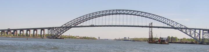
Syracuse here near the Oswego portal illustrates

the NYS Canals connection with the Great Lakes. This can be and is a portal to the Gulfs of Mexico and Saint Lawrence, and thence to all the watery parts of the planet.

Derrick Barge (DB) 4 here transfers dredge spoils from a scow to a bank needing bolstering; in the distance you can see the beauty of rural Mohawk Valley.

Tender #6, here near Albion, can no longer be seen unless you’re breathing air from a regulator 80′ down 2.5 miles off Shinnecock, a very distant corner of NYS.

Heading for the western end of the canal in Tonawanda, the aptly named DeWitt Clinton chugs along with purpose between Medina and Middleport.

Pittsford here stands by an ancient scow on another bank near the Rochester suburb of . . . Pittsford.

All photos, WVD, who has many more to share before the canal opens. I’ll avoid replication as best I can.
If you want to see more of the canal now, check out my April 2020 covid project, a virtual tour, here.
I’m moving eastward from yesterday’s post with my very subjective dividing of the NYS Canal system into zones. Very subjective, we then move into New York State’s third largest city–Rochester, which also happens to be what I learned about as “the city” as a boy. If someone worked “in the city,” that meant Rochester. In the photo below, technically in Greece, you can see the junction lock, the gates leading to a lock on the original and possibly the enlarged canal. Those iterations of the Erie Canal went straight here, the Barge Canal (the early 20th century iteration) forked off to the right, bypassing the city of Rochester.

I hadn’t considered what “bypassing Rochester” would look like, and my zones 1 and 2 were portions of the canal I’d never seen from the water. What it looks like is lots of bridges, with signs to places I knew but otherwise no traces, no familiar skyline.


Approach lighting system for the airport I took my first flight from,

but otherwise bridges, some beautiful . . .

some footbridges . . .

and others very serviceable vehicle and waterway structure . . .

with some people in view

as well as some current commercial buildings


and bridges some complete . . .

and trafficked


Certainly there are vestiges of industrial marine usage


not used in decades.

The creation of a kayak park and boat house is one of many transformations that make recreation the current Erie Canal’s industry.

Another transformation . . . silos into new uses. The tour boat in the foreground is Sam Patch, named for Sam Patch, of course.

I have a personal connection with the Pittsford canal front: as a boy, I harvested pickles for a neighbor, and one Saturday night I got to ride the farm truck to the piccalilli plant, right near the Schoen complex. If only time travel were possible and I could take that truck ride to the pickle factory again . . .
All photos by Will Van Dorp.


Will Van Dorp took the above photos between Pittsford and Medina.
Here was the first in what could be a series. And this foto I’m happy again to credit to Bob Stopper, some of whose photos can be seen here. I’m not sure what the naming system is for Canal Corporation, but some of their vessels are named for towns with locks–like Pittsford— along the Canal.

Ditto–in this foto from my sister—Waterford. By the way, the pre-eminent website for all things Erie Canal is fred’s at tug44.

In push gear and looking great at 85 years old, it’s Governor Cleveland.

If I still lived up that way, I’d get one of these, a buoy boat.

I don’t know how many of these there once were, but they are disappearing!

Click here for a foto of this deep looking Governor Roosevelt with her belly exposed.

There’s Grand Erie, and then there’s just plain Erie.

Then there are the self-propelled scows, but notice the difference in

engine exposure between this one shot by my sister and

SPS-54 shot by me

in August in Lyons.

Thanks to Bob and Lucy for these fotos. The last two are mine.


Recent Comments