Maersk Kentucky turns at least 90 degrees to starboard after passing under the Bayonne Bridge. Beyond Shooters Island lies the city of Elizabeth, NJ. More close-ups of Maersk Kentucky–eleven years running and a fifth of a mile long— tomorrow, but for now, she draws more than 30 feet max . . . and notice the mud trail she stirs up.
 Here’s a satellite view of Shooters Island; I believe the vintage foto of Shooters I posted the other day was taken from midway between the A pushpin and the New York ramp of the Bayonne Bridge. Click on the satellite foto to see where things lie in relation to Manhattan. Most of the container traffic through the port of “New York” operates through Port Elizabeth.
 Again, here’s a tightly-cropped foto of Shooters around World War 1, and here’s a
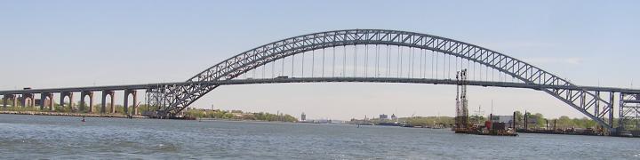
 foto I took from mid-Bayonne Bridge pedestrian way this morning, where I got my exercise.
 As I walked over, Maersk Kentucky traversed beneath, tugs Resolute at the bow and Elizabeth McAllister near the stern, making the turn and then

heading into Newark Bay, a half an hour
 or so behind Sea Land Eagle, roughly the same size as 1997-delivered ‘Kentucky. The land in the foreground is Bergen Point.
 All fotos by Will Van Dorp.
Related: See Johna and Vladimir’s homage to the Bridge here.


5 comments
Comments feed for this article
November 21, 2011 at 9:26 am
JED
Wow – MAERSK KENTUCKY is virtually EMPTY
November 21, 2011 at 9:40 am
tugster
you, sir, have pointed out an uncommon economic indicator. not good? unless they need all the space to carry out exports?
November 21, 2011 at 9:17 pm
JED
Did she leave loaded to the gills? That might make a difference. I just remember Port Elizabeth being JAMMED with ships that were JAMMED with containers.
November 22, 2011 at 8:19 am
tugster
good question . . . but i didn’t catch her headed out.
September 26, 2012 at 6:42 am
Towboat of Opportunity | Cumberland Soundings
[…] As an aside, she is now pushing INTO the Flood. Not sure how that happened or where the change occurred. Not unheard of. There’s a spot off Shooter’s Island at the junction of The Kills in Staten Island where the current does that. West to East in the Arthur Kill – East to West in the Kill van Kull. Made for WONDERFUL VHF Radio conversations as Convention dictates that the vessel burdened with a Fair Tide is allowed right of way. Tugster provides a shot of Shooter’s Island in his post Shooter’s Island Then and Now […]